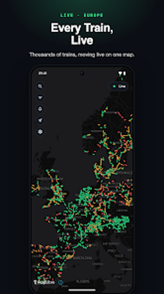
Map-based live tracking of European passenger trains
Displays live passenger trains on an interactive map that plots actual rail geometry and calculates GPS-based positions, giving a moving picture of journeys across Europe. Alihan Aktay developed the Android app as a mobile navigation and monitoring companion, combining official transit feeds with rail geometry to show next stops, platform assignments, and delay updates. It suits commuters, long-distance travelers, and rail enthusiasts who need visual, up-to-the-minute train position and schedule context.
What the app actually does for rail travellers
Train Radar: Train Tracker renders passenger services on a live, interactive map, showing trains in motion rather than static points. The app merges official transit data with real rail geometry and uses GPS-based position calculation to place trains on tracks, and it displays next stops and scheduled arrival times when you tap a service. That combination is designed to give visual context for journeys and platform information directly on a mobile device.
How accurate and reliable the live positions are
The app calculates live positions using a mix of official feeds and GPS where available, so positional accuracy depends on the underlying operator data. The source notes that users appreciate the real-time tracking but that data quality varies by railway operator, which means displayed locations and delay indicators reflect the freshness and precision of those feeds rather than the app itself.
Device compatibility and connection model
The tool runs on Android and is also compatible with iPhone and iPad, operating as a standalone mobile client that requests live updates over a stable internet connection. It does not require any direct hardware pairing or device modification; instead, it aggregates transit feeds and renders them locally on the device's map view, so you can check train movements from a smartphone using mobile data or Wi-Fi.
When to use it and where it does not substitute official sources
The app is suitable for commuters checking platform assignments and travellers tracking delays visually, and for enthusiasts who want continuous map playback of rail traffic. It is not an official railway operator tool, so schedule and platform details should be cross-checked with carrier communications for operational decisions; the developer lists the app as independent and not affiliated with railway companies.
A clear visual companion for on-the-go train awareness
The app serves well as a visual companion for people who need map-based situational awareness of passenger trains across Europe, especially when you want to follow a journey or inspect platform information on a phone. Users should treat it as an aggregated view that depends on external feeds, and confirm critical timing or platform changes with the railway operator before relying on it for travel-critical decisions.